|
 PDF Maps PDF Maps
-City
Street Map
-City Subdivision Map
-Snowmobile Route
-Ward and Precinct Map
-Refuse Pickup Map
-Elementary School
Boundaries
-Middle School
Boundaries
-High School Boundaries
-Truck Route Map
|
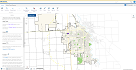
New Interactive Mapping Application
Our new interactive mapping application is built to work on any device so please try it out on your computer, tablet, or smartphone. Don't forget to bookmark the address and/or add it to your favorites.
By clicking the above link, you are agreeing to the following:
All dimensions, descriptions, measurements, boundaries and data contained in
this nonstandard document are included for general information only. No
warranties or covenants are made or given by the City of Grand Forks. Any
user must confirm the accuracy of the same with official records, and/or by
survey.

GIS Services Open Data Warehouse
Spatial Data Download
Open Data warehouse is a place where you can download
GIS data for use in your own mapping and GIS applications
By clicking the above link, you are agreeing to the
following: All dimensions, descriptions, measurements, boundaries and data contained
in this nonstandard document are included for general information only. No
warranties or covenants are made or given by the City of Grand Forks. Any
user must confirm the accuracy of the same with official records, and/or by
survey.
Apps and Maps
Check out our collection of apps and webmaps below. We are working to expand our collection so please check back frequently.
|